

The Need for Precise Coastal Insights in the Face of Extreme Weather Events
As climate change intensifies coastal hazards, insurance and risk modeling firms are increasingly seeking better tools to quantify storm surge vulnerability. While inland flooding models have matured significantly, coastal surge risk is subject to uncertainties driven by outdated datasets, uncertain terrain information, and dynamic changes to shorelines.
Collaboration Overview
Ocean Ledger, a geospatial data company spun out of the German Aerospace Center and Lloyd’s Lab Cohort 14 alum, delivers location-specific, frequently updated data on shoreline movement, bathymetry, and coastal defenses using satellite analytics and machine learning. KatRisk, a leader in probabilistic flood and surge modeling, provided a digital elevation model (DEM) and location-level loss outputs to test whether enhanced hazard data would yield more accurate flood risk predictions.
The objective: determine how Ocean Ledger’s enhanced elevation model and shoreline intelligence would influence KatRisk’s surge model outputs, highlight shifts in coastal vulnerability, and corresponding increase or decrease in under and over estimated loss potentiality.
What We Set Out to Test
Ocean Ledger integrated its updated DEM and shoreline analysis into KatRisk’s stochastic storm surge model to evaluate potential shifts in surge risk and associated losses.
This specific integration of Ocean Ledger’s coastal erosion data into the KatRisk storm surge risk and loss model represents an overall conservative increase in risk as only those locations with decreased elevation experience an increase in loss. In reality, a changing coastline may significantly increase surge risk to communities further upshore due to changing coastal morphology and how those alterations affect the geophysical fluid dynamical models utilized in the KatRisk surge model. Future work, enumerated below, will explore how to further capture the upshore risk, such as Ocean Ledger data being directly integrated in the fluid dynamic model stage.
The above methodological limitations, while significant, still provide a useful estimate of the increase in loss as represented by changing Average Annual Loss (AAL) provided by the KatRisk storm surge risk and loss model. This approach provides significant utility to clients, allowing for a simple and scalable methodology for evaluating areas of concern and how changing coastal elevation affects property-level and regional risk metrics.
What We Found
Despite the conservative approach, Ocean Ledger’s input generated meaningful insight into where risk was underestimated:
- $1M in underestimated risk: Properties that were previously underpriced due to outdated topographic inputs showed notable increases in AAL, totaling nearly $1M in one region.
- Localized risk shift: The most significant upticks in AAL were spatially correlated with areas experiencing erosion or elevation loss, highlighting the importance of precise local data.
- Meaningful shoreline change:
- Within 5 years, shoreline shifts of up to ±100 meters were observed.
- 95% of eroding coastlines showed losses between –107m and –4.3m.
- 95% of accreting coastlines showed gains between +4.9m and +163.8m.
Visual 1: KatRisk shoreline position vs. corrected position by Ocean Ledger.
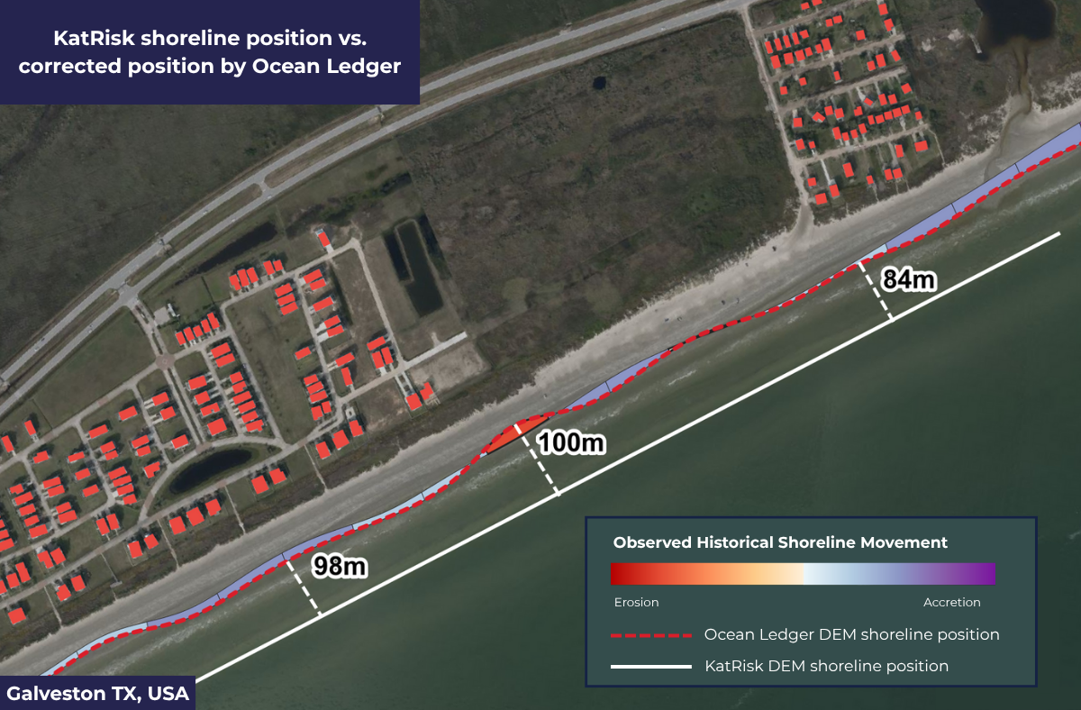
Key takeaways: At some locations, the shoreline position between Katrisk’s DEM and Ocean Ledger’s differed by 100 meters. It’s crucial to note this was not only due to actual shoreline changes but instead structural errors in the older digital elevation model. Structural errors in creation of the digital elevation model can be due to sensor errors, false returns, processing of the continuous surface from discrete points, post-processing smoothing, errors in tidal correction. This is clear when we overlay the actual shoreline change extracted by Ocean Ledger (erosion & accretion) during the time period.
Visual 2 - Surge loss property-specific under & overestimation linked to shoreline elevation changes and slope shifts.
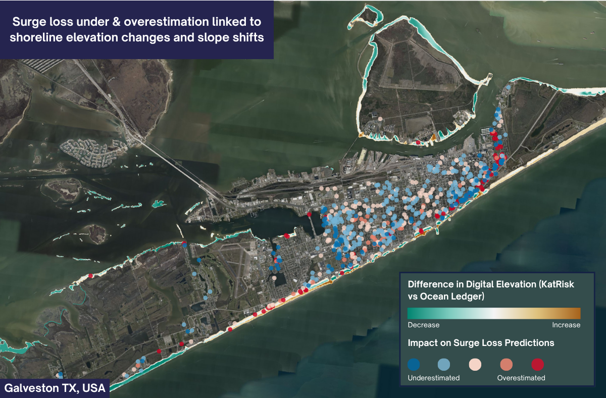
Key takeaway: Blue dots show where there were less losses (overestimated) than initially projected. Red is where risk was underestimated.
Visual 3 - Surge loss under & overestimation linked to shoreline elevation changes and slope shifts, zoomed in.
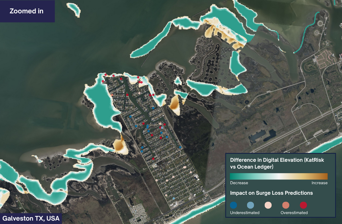
Key takeaway: Darker turquoise corresponds to elevation decrease and darker brown corresponds to elevation increase. Highlighting higher losses in red dots and how subtle terrain shifts can have large loss implications.
Broader Implications
1. Ocean Ledger as a Crucial Model Enhancer
Given the current limitations in re-running vendor surge models, Ocean Ledger now provides a comparable, standalone surge risk view. This output allows insurers and modeling teams to refine existing loss models, like KatRisk’s, without deep integration.
2. Addressing Gaps in Public Datasets
Most coastal flood models still rely on outdated FEMA, NOAA, or USGS datasets that have updated cadences of multiple years, yet coastlines are changing at a much more rapid rate, likely resulting in under and or overestimation of risk which can result in increased premium and/or loss of policy due to property incorrectly not meeting underwriting criteria. Ocean Ledger fills this gap to allow for more modern underwriting by building bottom-up shoreline, elevation, and coastal defenses (man-made & natural) using advanced satellite analytics that can improve the granularity of KatRisk’s surge hazard layers, offering sharper risk scoring and exposure insight.
3. Scalable Underwriting Precision
For underwriters using KatRisk in high-uncertainty zones, like barrier islands, rapidly changing coastlines, or reclaimed land, Ocean Ledger’s data provides a reliable, plug-in tool to boost confidence in pricing and risk selection.
Use Case for Surge Model Calibration
In a crowded space with many flood and cat vendor model vendors, Katrisk and Ocean Ledger have set the foundations for a “co-modeling” approach that empowers clients with up-to-date intelligence and greater insight without requiring a full overhaul of internal or vendor flood models.
Ocean Ledger’s surge risk and shoreline metrics can be used to:
- Calculate surge damage deltas (% difference) between RMS, KatRisk, and Ocean Ledger uses EP curve/ELT blending (Starting View vs. Adjusted) allowing for derivation of adjusted AALs and further analytics such as TVaR
- Calibrate flood scores & AAL in coastal zones having outdated or uncertain model inputs.
- Identify physical and environmental drivers for surge risk severity to advise on risk management and communicate pricing adjustments.
KatRisk’s flexible model architecture makes it easier for teams to apply these enhancements without disrupting existing workflows.
Future Work
The KatRisk and Ocean Ledger partnership revealed that enhanced shoreline and elevation intelligence from Ocean Ledger can meaningfully inform loss modeling. Ocean Ledger will continue to refine its surge & shoreline models to enable actuaries and modellers to seamlessly adjust Katrisk’s Flood Score and AALs. The two companies will explore how forecasted shoreline movement (erosion, accretion) could be used to inform flow direction and which areas are likely to be higher or lower flood risk to establish a ceiling of potential economic or insured losses under various scenarios.
The shared goal is to empower governments, risk advisors & insurers to confidently select, price, and manage risks in some of the most surge-prone areas in the world.
In a world of uncertain data and growing coastal risk, Ocean Ledger and KatRisk offer an innovative, flexible toolkit for those who want to stay ahead of the curve.
About Ocean Ledger
Ocean Ledger is a specialist geospatial service provider offering a stochastic surge model based on proprietary, cutting-edge methods that extract present-day and historical shorelines, seabed and natural defenses; therefore identifying critical drivers of coastal flood severity. The company delivers a transparent view on coastal physical and environmental risk to provide assessments for insurance & property valuation while reducing resources on large site surveys. Ocean Ledger supports public and private clients exposed to financial volatility from extreme weather, erosion and coastal flooding by targeting and monitoring mitigation strategies, enabling competitive underwriting in high-risk coastal zones. For more www.ocean-ledger.com.
About KatRisk
KatRisk is a global leader in climate catastrophe risk modeling, providing advanced solutions to insurers, governments, and financial institutions. With models covering over 190 countries, KatRisk offers high-resolution risk assessments for inland flooding, storm surge, tropical cyclone wind, severe convective storm, and wildfire. Utilizing state-of-the-art probabilistic modeling, KatRisk stands out for its speed, technical excellence, and transparency. As a pioneer in integrating climate change scenarios, KatRisk helps clients enhance resilience and financial sustainability in an increasingly volatile environment and their proprietary financial model enables smarter underwriting, investment, and mitigation strategies. For more www.katrisk.com.
