

For capital markets, the success of nature-based sovereign debt is defined by many factors, of which there are too many to list here. First, and most importantly, is ‘government’ buy-in with financial and political ‘structures’ in place to support the requirements of whatever instrument is used. At the time of structuring, and post-issuance, monitoring and reporting are fundamental to instill continued trust in these controls.
In this case study, we discuss the importance of the mapping work, the process and learnings as it relates to Belize’s Blue Bond program. In a world consumed by AI-native disruption across industries, we highlight the importance of quality reference data and verifiable geospatial modeling enabled through deep learning, sophisticated geospatial engineering and localized insight (ground-truth data). In simple terms, this approach enables a cheaper, faster and better product to underpin high-quality reporting for financial products linked to environmental and physical risk.
The catalyst: Belize's Blue Bond
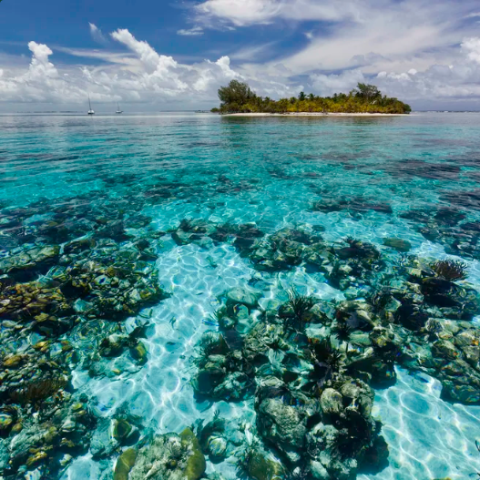
Belize’s economy relies heavily on tourism, with 40% of economic output coming from the industry and one in every 10 workers employed in the fishing sector. Ocean conservation is undeniably crucial for this country nestled between the Caribbean Sea and the rainforest on the eastern coast of Central America. The Government of Belize has been advancing its commitment to protect 30% of its ocean space, including priority to coral reefs. As part of the Resilient Bold Belize (RBB) Initiative and the People-Centric Conservation Agenda, this initiative supports Belize’s national and international conservation goals and underpins the development of the Belize Sustainable Ocean Plan (BSOP), a framework designed to guide sustainable management and biodiversity protection across the country’s marine environment.
In 2020, with the compounded challenges brought by a public debt reaching US$2.1 billion, Hurricane Eta and the COVID-19 pandemic, Belize required a quick, reliable solution to face their debt servicing obligations and disaster response. The first step was to secure financing and restructuring support. The NatureVest team at The Nature Conservancy (TNC) set up the Belize Blue Investment Corporation (BZBIC). This entity purchased all of Belize’s privately held sovereign debt (over US$500 million) via issuance of a blue bond purchased by investors secured through Credit Suisse. The debt servicing payments are made by Belize on a semi-annual basis over a 20-year term.
As part of the agreement, a trust fund, set to mature to $23.4 million by 2041 (1.27 percent of GDP) was established to protect its coral reefs. The bond was structured to unlock around US$180 million over the next 20 years to fund environmental conservation commitments of the Government of Belize. Specifically, Belize has promised to spend roughly US$4 million a year for conservation. The inclusion of the conservation trust played a key role in securing support from a binding majority of the bondholders for a restructuring that imposes a 45 percent haircut on the principal of the 2034 bond.
As part of the blue bond commitments, the Belize Government, in particular the Blue Bond Team, and WWF, have to supply a highly robust map of Belize’s ecosystems to prioritize conservation efforts and set a ‘baseline’ for monitoring and reporting. Previous mapping efforts highlighted both the benefits and challenges of satellite analytics for ecosystem mapping in the region.
Ocean Ledger was engaged as the data provider to undertake this work in collaboration with the Blue Bond and Finance Permanence Unit (BBFP), the Coastal Zone Management Authority and Institute (CZMAI), the Belize Fisheries Department (BFiD), and WWF. Ocean Ledger classified over 7,800 km² of marine territory to pinpoint national conservation priorities. While traditional mapping would have taken five years and cost roughly US$2 million, our geospatial modeling delivered a robust baseline in just weeks. Below we outline the project steps and key learnings.
The process
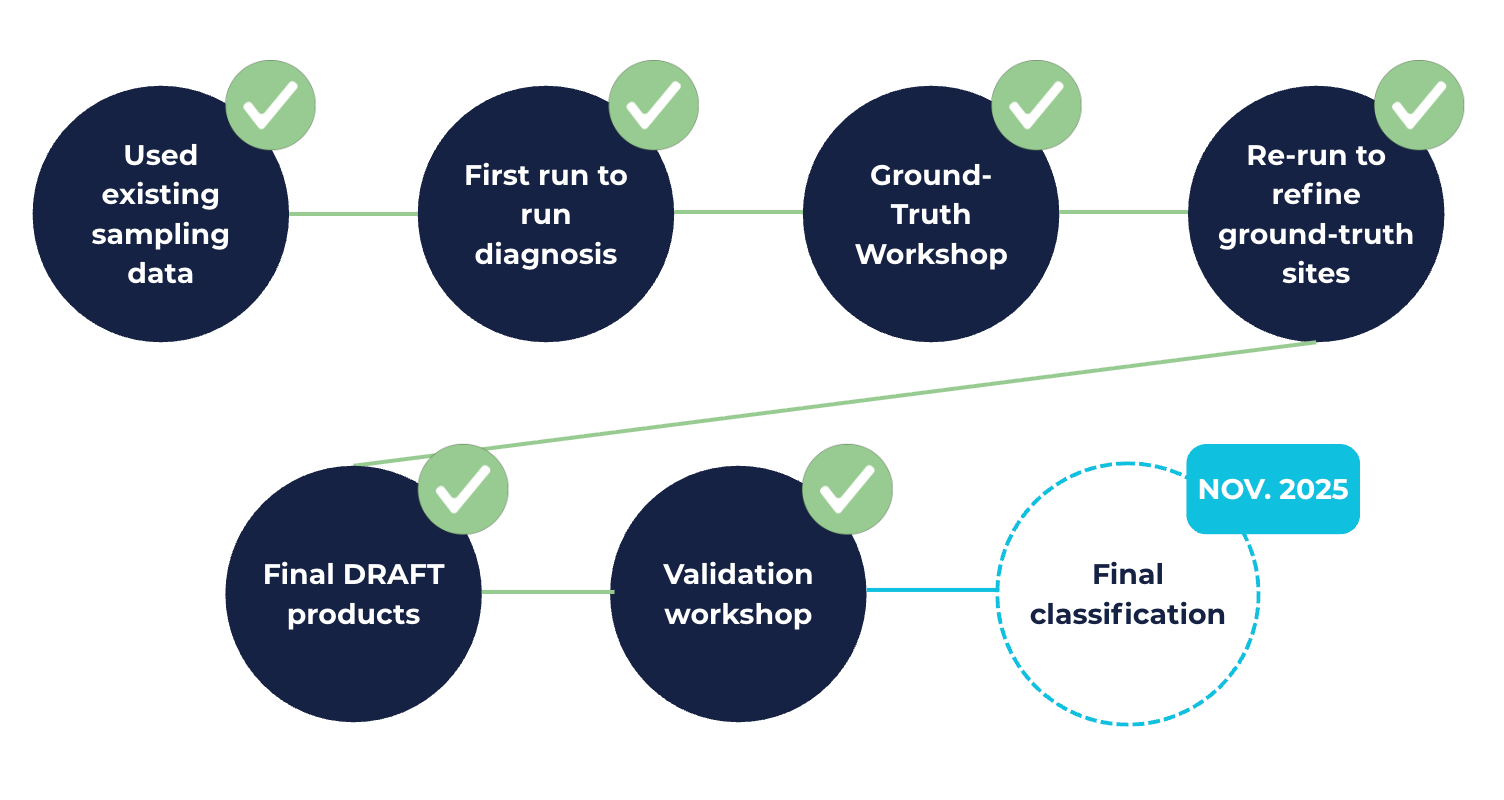
Step 1: The first step was creating a preliminary classification, or map, of the marine habitats along the coastline. Ocean Ledger acquired satellite imagery from two main sources: Sentinel-2 and PlanetScope, as they offer different spatial and temporal resolutions, or ‘lens’ of observations that can be used for training. The data went through several cleaning, alignment and processing steps in order to become ‘usable’. As part of the analysis, bathymetry was required to help train the marine habitat classification (depth is the variable). Estimates were computed using two approaches: a ‘physics-based’ approach, and the application of machine learning regression to achieve the best results.
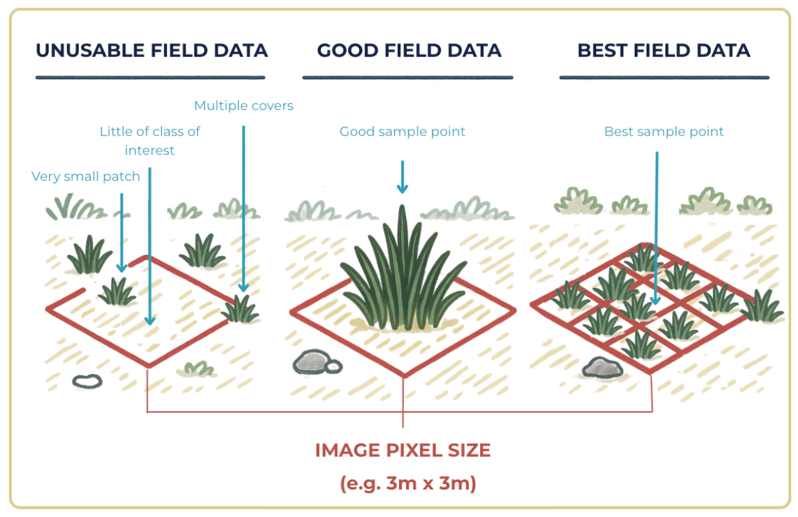
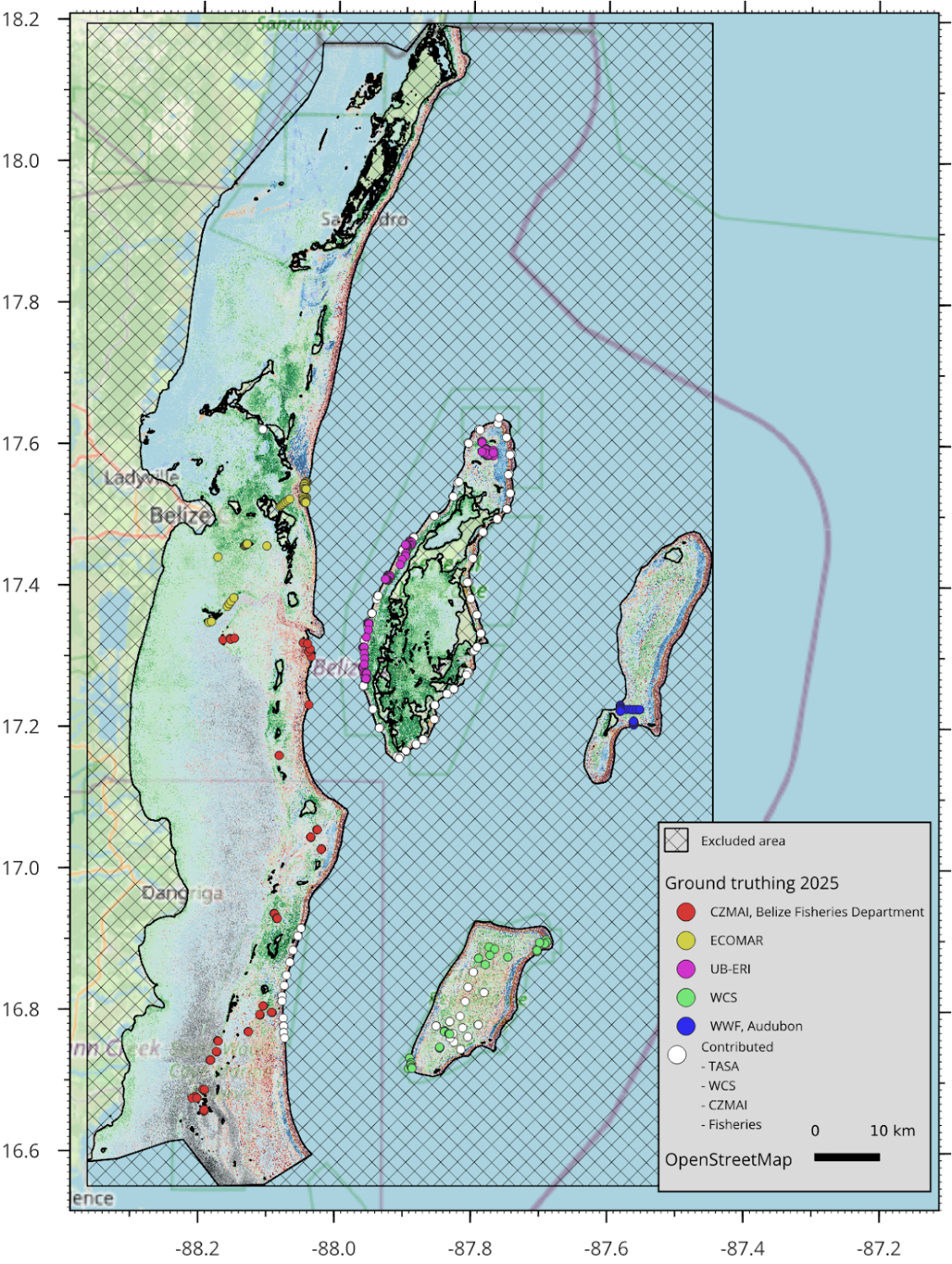
Step 2: Ocean Ledger presented an initial classification which included detailed spatial uncertainties. This was presented to the key project stakeholders to target field data collection. The team also instructed what data is most relevant to be collected and how it should be stored, to best align with geospatial modeling. A guide on combining ground-truth and remote sensing approaches for marine mapping can be found here.
Without this step, teams can be deployed in the wrong area, collect too much, too little or the wrong kind of data. Most importantly, it may be collected but not easily machine-readable, which means it won’t effectively ground-truth the model.
Step 3: Beyond field data collection, ground-truth data was collected using a tool called SeaSketch which enables experts to visualize the marine classification and comment on where they believe the model was correct or incorrect. This was a rapid form of ground-truth that complements field data measurements.
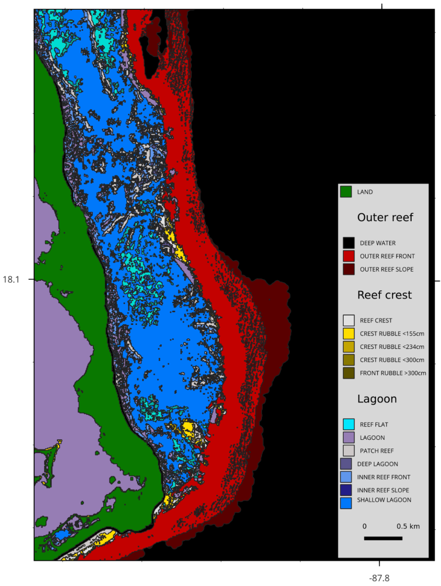
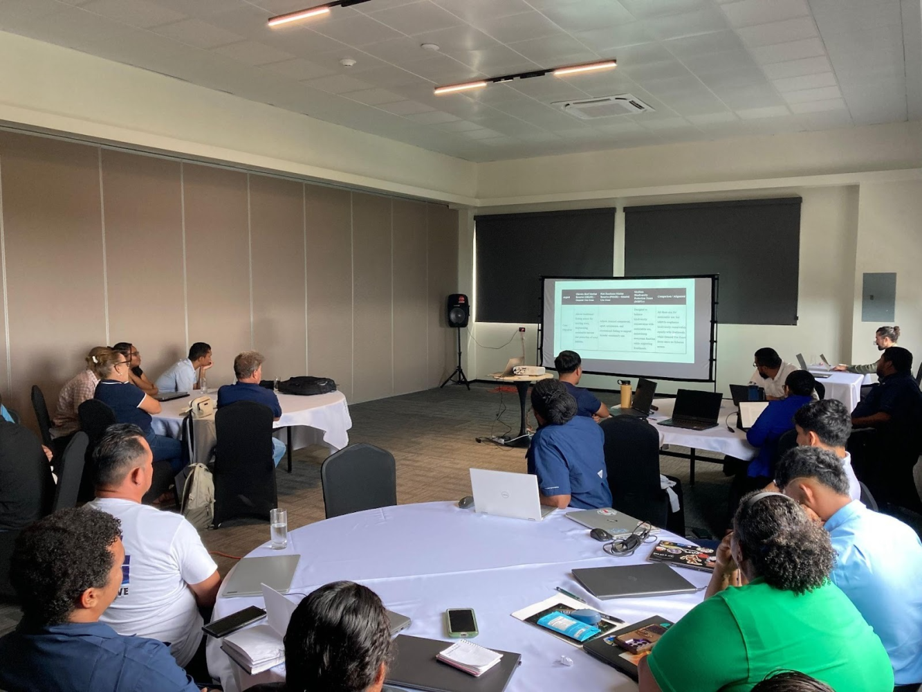
Step 4: With the new field data and expert input using SeaSketch, the classification was rerun and showed significant improvements across all classes. Geomorphic zones were also computed to identify terrain forms (slopes, crest, pinnacles, and flats). The maps were presented at a ‘Validation Workshop’, a formal gathering to ensure these maps were reviewed by all relevant stakeholders. The Government of Belize, through the BBFP and in collaboration with Ocean Ledger, convened governmental and public stakeholders, coral reef practitioners and marine management experts to refine the draft of the marine habitat classification products developed by Ocean Ledger.
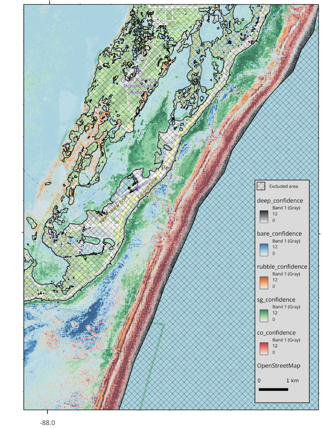
Step 5: The marine habitat classes were run for a final time, incorporating the feedback from the validation workshop and any remaining field data. These classes, while modelled separately, were combined into a single map. It included spatial confidence thresholds for each class.ocations of ground-truth ‘validation’ data either through expert workshops and fieldwork.Figure 14. Benthic cover predictions layered by class confidence for San Pedro. Areas with no apparent prediction have low confidence scores across multiple classes.
Key Learnings
Remote sensing for marine ecosystem mapping
Mapping tropical marine ecosystems is feasible using public and commercial satellite imagery, though each incurs trade-offs, with sensor- and source-specific benefits and limitations. Whilst recent cloud computing advances allow public data to be processed at scale, it should not be overlooked that rigorous data preparation is essential to handle noise and achieve the precision required. Even with access to modern computation this remains an intensive task. Accurate marine mapping requires filtering and processing very large raw image datasets, to correct for not only atmospheric but also water surface and water column interactions. Combination of multi-temporal data allows advanced automated filtering and is particularly effective for removing seasonal turbidity and waves; which impose a limitation when using commercial data sources that can appear attractive for other properties, particularly the potential improvements to spatial resolution.
Modeling & data constraints
The project utilized probabilistic machine learning, alongside advanced approaches to feature creation, including deep learning, and spatial texture analysis. To benefit properly from these approaches when operating across a large area of interest requires substantial amounts of training data, so that regionally and depth-varying characteristics of imagery can be captured effectively. It is often too costly or logistically difficult to collect this information solely through field work. Furthermore, aligning field data with satellite imagery presents significant technical challenges, with the combined spatial error in both sources having the potential to confound the value of point labeling.
The collaborative solution
To bridge this gap, the project generated the necessary training data using a collaborative platform (SeaSketch). BBFP led sessions with local experts to translate their deep knowledge of the ecosystems and marine environment in Belize’s territorial waters into a geospatial product. This allowed modelers to combine technical insights regarding the data and modeling with on-the-ground expertise; we consider this as a "best of both worlds" approach that was able to rapidly generate the quantity of survey data required whilst limiting cost. Doing so allowed field data collection efforts to focus on those areas of highest value, and the preservation of this data for independent validation so that the resulting data end products can be properly interpreted. The Ocean Ledger team commends BBFP and the Belize marine conservation community for leading this process.
Outcome and next steps
So, what is this data being used for? Where’s the return on investment? Aside from monitoring and reporting, it helps prioritise which areas across the EEZ should be conserved and how, based on their location and geomorphology. Moreover, it can be used to refine parametric policies (discussed below) and attract new outcomes of results-based investments. Finding alternative incentives to diversify long-term sustainable marine management is crucial. The ability to show that there has been ‘progress’, in terms of ecosystem extent/health improvement due to financing efforts, is a highly coveted but often difficult to achieve in practice for marine ecosystems. It’s Step 1 to establish additionality, before attracting further result-based investment, such as biodiversity credits.
Beyond blue bonds: the role of insurance in unlocking blue finance
Whether it’s bonds or credits, financial instruments require assurances to all stakeholders involved, particularly investors. Political risk is required for all transactions but depending on the country, additional products for extreme events help the country or businesses to economically recover faster. MS Amlin’s political risk product for Ecuador’s blue bond is a great example.
To protect Belize’s semi-annual debt servicing against severe climate events, WTW developed a parametric "wrap" for the bond.
Traditionally, insurance is "tail-end Charlie", the final step in a capital restructuring or raise. This sequencing is exactly where most bespoke blue finance deals come unstuck. With highly complex and novel financial restructuring program, insurance must be the first step, not the last. And it can come in all forms to protect bondholders, businesses, communities, and even natural assets like the ones in Belize.
As alluded to above, these high-fidelity baseline should have dual-fold purpose to maximize the ROI, particularly because it can be easily updated. In the parametric world, it can serve as an objective, high-fidelity baseline to support existing and new parametric program for the natural asset itself. While there have been varying levels of success in such program, countries and industries that rely on natural assets for fishing and tourism can ensure that post-hurricane, resources are available to assess the extent of damage.
Parametric products require a transparent view of what resource is being protected and what ‘trigger’s a pay-out. High-resolution maps allow underwriters to move beyond generic or outdated maps to identify specific, high-value assets and establish a "pre-event" baseline, allowing for an objective measurement of "health" before a disaster occurs.
Post-event, these habitat maps can be updated within days to get an accurate post-event assessment and target on-the-ground resources.
A major challenge is basis risk, the gap between the insurance payout and the actual loss on the ground:
- For spatial confidence, Ocean Ledger’s model includes confidence thresholds for each habitat class. This allows insurers to trust that a "trigger" in a specific coordinate actually corresponds to a coral reef rather than sand or rubble.
- For the best resolution and accuracy, using a combination of Sentinel-2 and PlanetScope imagery enables the filtering of seasonal noise, such as turbidity and waves, which might otherwise cause "false positive" triggers in lower-resolution models.
Ocean Ledger’s take
Our view is not to bring in insurance, where it’s not needed, but to highlight technology that has outpaced traditional parametric programs. And in the case of a country (or company) whose economy is heavily reliant on natural resources, proactive, bespoke risk transfer is an opportunity.
By blending local knowledge with advanced satellite technology, this project proves that ambitious conservation is achievable at scale. Local knowledge and input goes far beyond increasing certainty across the geospatial models for each habitat. It’s crucial for national buy-in and alignment, ensuring everyone’s expertise is integrated with observational data in a methodical, objective manner.
It’s also crucial for multi-stakeholder alignment, specifically between insurers, banks and governments, where sometimes data reporting standards can be beyond the remit of a government. As with any transactions, third-party, verifiable data builds trust and transparency.
Belize is leading the way and shows that high-quality data collection and mapping efforts do play a pivotal role through blue financing programs.
If you’d like to learn more about this project or discuss another project, please don’t hesitate to get in touch.
Acknowledgments
A special thanks to the Government of Belize, the Belize Fund for a Sustainable Future, and WWF, Blue Bond and Finance Permanence Unit who co-funded and coordinated the initiative. Also, to Melanie McField of Healthy Reefs Initiative and Emil Cherrington, PhD of The University of Alabama whose contributions have made a true difference. Jamani Balderamos and Delwin Guevara charles, from the BBFP and CZMAI, thank you for giving us the opportunity to support your team.